Integrated assessment models (IAMs) are commonly used to explore the interactions between different modeled components of socio-environmental systems (SES). They are particularly popular in climate change impacts studies in which climate models are linked to terrestrial process models such as hydrological or lake models to determine impacts of changes in climate on water resources and water quality.
Most IAMs are built in a tightly-coupled framework so that the complex interactions between the models can be efficiently implemented within the framework in a straight forward manner. However, tightly-coupled frameworks make it more difficult to change individual models within the IAM because of the high level of integration between the models. In a loosely-coupled architecture, however, each model runs independently, without access to the current state of the SES in system memory or each other as shown in the Figure below. The initial conditions of the SES required by each component model are provided by input files. The model then runs to completion for a given time frame. After execution, the model updates the SES system state by providing updated output files. Within each time frame, the models execute in a cascade, with the models that are most sensitive to the current SES state executing at the end of the cascade.
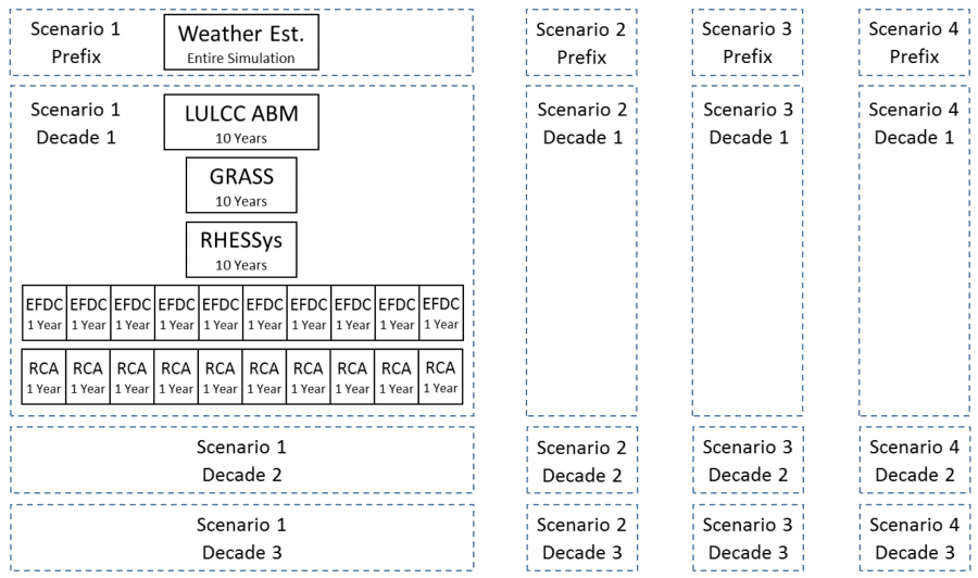
The independent nature of each scenario and of each annual modeling task, for certain models, is exploited to increase the parallelism of the IAM workflow. The workflow (depicted in the figure below) is defined as follows:
- The weather estimator runs once for each climate scenario and projects a number of daily weather variables for the entire simulation period as required by the lake hydrodynamic model, EFDC, from the daily projected temperature and precipitation of each climate scenario.
- After the weather estimator is queued, the workflow begins looping through the tasks in a decadal time step. The models are broken into decadal time steps which corresponds to decadal feedback between the models. The time step of a decade has been initially chosen as a tradeoff between the temporal precision of the feedback data available and the additional computational resources required as the time step decreases. The first task in the decadal loop is the Land Use Land Cover Change Agent Based Model (LULCC ABM). The LULCC ABM relies on downscaled climate data, outputting land-use maps for the region every 5 years.
- GRASS is a Geographic Information System (GIS) software suite used to processes the LULCC ABM land-use maps into a worldview format which is required by the hydrology model, RHESSys, for each modeling run.
- EFDC uses daily discharge values from RHESSys and projected weather variables from the weather estimator. Due to the lake freezing each winter, the hydrodynamics are essentially reset annually, and thus, each year-long run of EFDC is independent of each other and starts with the same frozen initial conditions.
- The final modeling step, the lake water quality model (RCA), requires the output files from EFDC along with estimates of nutrient levels contained in the discharge generated by RHESSys as input.
References
[1] Zia, Asim, et al. “Coupled impacts of climate and land use change across a river–lake continuum: insights from an integrated assessment model of Lake Champlain’s Missisquoi Basin, 2000–2040.” Environmental Research Letters 11.11 (2016): 114026.